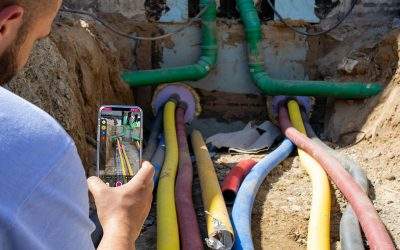
Measuring house connections via smartphone and GNSS
Hexagon expects the integration of the NAVA app to boost innovation among its customers in the infra-structure sector. “The NAVA app ideally supplements our broad HxGN NetWorks product portfolio for utilities, and communications during the process of documenting and measuring house connections,” says Maximilian Weber, Senior Vice President, EMEA, Hexagon’s Safety, Infrastructure & Geospatial divi-sion. In particular, network operators and the contracted civil engineering companies are using it to digi-tise the process around the house connection documentation and the measurement. “The home connec-tion is a benchmark of digitalisation for network operators,” adds Stefanie Mollemeier, Managing Direc-tor of Mettenmeier GmbH, “and the Hexagon customers will be delighted with this smartphone app.” Even multi-section house connections can be documented in one process, including line display. The app uses the latest technologies such as augmented reality, 3D, image documentation and automation. At the same time, the NAVA app opens the way towards a “glass pavement”. Due to the simplicity and func-tional maturity of NAVA across iOS and Android platforms, every field crew member can record the exact positions of underground installations directly after the pipe has been laid, take photos and close the trench again promptly. This avoids a backlog of orders or an inaccurate measurement of the existing installations only after the trenches have been backfilled. Another advantage of the solution is the GIS interface already implemented by Hexagon: directly after the house connection has been measured with the smartphone, the digital sketch including all order-related data and components is sent directly and seamlessly via the cloud to the NAVA Manager and from there to the geospatial network information system. For users of Hexagon’s portfolio HxGN NetWorks, this results in a noticeably shortened process chain with a simultaneous reduction in the error rate in the house connection documentation. Missing or illegible measurement data and the resulting queries are now a thing of the past.
While NAVA with its photogrammetric approach already delivers measurement results in compliance with German industry standards and works even in GPS shadows, Mettenmeier has now expanded the solution with the mobile GNSS antenna Leica Zeno FLX100 from Hexagon. This enriches the measure-ment with absolute coordinates. To do this, the smartphone is coupled to the receiver via a universal handheld cradle and the free Leica Zeno Connect utility is installed on the smartphone. NAVA thus achie-ves horizontal accuracies of less than two centimetres via the multi-frequency reception and the correc-tion signal used. In addition, the augmented reality of the NAVA app enables an intuitive check of the position quality directly on site. The advantage of the absolute GNSS coordinates is that measurements can now also take place in poor visibility or in larger geospatial dimensions, for example in track sur-veying, cable and pipeline routes or very long house connection lines.
After NAVA was presented for the first time at the user conference of Hexagon’s Safety, Infrastructure & Geospatial Division in October 2022 in Berlin, the two companies are already planning to present the integrated solution in a joint webinar.

(copy-righ: Mettenmeier)
About Hexagon
Hexagon is a global leader in digital reality solutions, combining sensor, software and autonomous tech-nologies. We are putting data to work to boost efficiency, productivity, quality and safety across indust-rial, manufacturing, infrastructure, public sector and mobility applications. Our technologies are shaping production and people-related ecosystems to become increasingly connected and autonomous – ensu-ring a scalable, sustainable future.
Hexagon’s Safety, Infrastructure & Geospatial division improves the resilience and sustainability of the world’s critical services and infrastructure. Our solutions turn complex data about people, places and assets into meaningful information and capabilities for better, faster decision-making in public safety, utilities, defense, transportation and government.
Hexagon (Nasdaq Stockholm: HEXA B) has approximately 23,000 employees in 50 countries and net sales of approximately 4.3bn EUR. Learn more at hexagon.com
About Mettenmeier
Mettenmeier is a software company headquartered in Paderborn, Germany, and currently employs ap-proximately 200 skilled professionals. As a provider of IT solutions and consulting services, Mettenmeier is one of the top addresses in the energy and water industry. The focus is on the areas of GIS and network data, asset and work management as well as the design and support of service processes. Learn more at www.mettenmeier.de
